
Tasman Dr Update
On July 29th, 2025, Sunnyvale City Council chose the Alt 1 Multi-Use Pathways design on Tasman Dr between Fair Oaks Ave and Vienna Dr. They also chose to preserve the existing lane closure pathway.
This monumental achievement was only possible through extensive work by Sunnyvale Safe Streets and local residents. We appreciate everyone who spread the word, spoke at public meetings, sent emails to City Council, signed the petition, and helped in other ways. Our efforts paid off spectacularly. Hundreds of emails were sent, and at the City Council meeting 46 people from various backgrounds and ages spoke up in support. City Council saw this incredible grassroots support, and that gave them the confidence to push forward.
The City is now entering the detailed design phase of the project, and then they will apply for grant funding. Sunnyvale Safe Streets will continue to keep tabs on this project to ensure Tasman Dr becomes safe as soon as possible.
To stay in the loop, please go to the bottom of the page and join our newsletter.
EXISTING CONDITIONS
-
Tasman Dr has no continuous sidewalks or bike paths.
-
People frequently walk and bike in the gutter next to car traffic traveling over 40 mph.
-
Tasman Dr has blind curves, which prevents drivers from seeing pedestrians and bicyclists.


THE SOLUTION

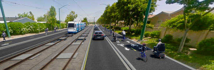
The City is proposing to replace the outer traffic lanes with wide bi-directional walk/bike pathways. See this simulation. We support starting with Phase 1 from Fair Oaks to Vienna. Here are the benefits.
-
Adds elevated multi-directional paths on both sides of Tasman between Fair Oaks and Vienna, making it safe for everyone to walk and bike to local shops, schools, trails, & transit stops. This project will right a historic wrong. You can learn the history of Tasman Dr here.
-
This project is our only chance to replant trees on Tasman (per 3 City Councilmembers).
-
Traffic on Tasman will be the same or better.
-
No impact on emergency response times.
See the Project Details section for more.
LOCALS WANT THIS PROJECT
There is strong local support for this project. A City survey found that 88% of Sunnyvale residents support replacing the outer vehicle lanes with dedicated walking and biking facilities (source).
Already, 100s of people walk and bike on Tasman Dr every day. They travel not only on the existing temporary pathway, but also in the street with cars. There are 4000-5000 residents along this part of Tasman Dr. If some are willing to walk and bike in the street now, imagine how many more would walk and bike if the road was safe!

BENEFITS

Mobility
This project will enable residents to safely and conveniently walk, bike, scooter, etc. to local destinations

safety
This project will save lives by separating vehicles from vulnerable road users
Connect to trails
The proposed multi-use pathway will connect to the East Channel Creek Trail and future Lawrence Expy Multi-Use Path
Sustain future population
As the population grows, residents will have safe, efficient, and sustainable alternatives to driving
IMPROVE INTERSECTIONS
The project will retime light signals to optimize intersections
Project Details
WHAT ABOUT TRAFFIC?
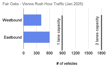
Tasman Dr is overbuilt for vehicles. Between Fair Oaks Ave and Vienna Dr, the vehicle volumes are not high enough to justify 2 lanes. This is true during the entire day and during rush hour. Removing a lane in each direction will not have an impact on drivers (source).

The Fair Oaks intersection will also be retimed, resulting in less delay. Short wait times (in green, <= 35 seconds) will increase by 25% and long wait times (in red, 55+ seconds) will decrease by 50%, even at rush hour.(source).
EMERGENCY RESPONSE TIME WILL NOT BE IMPACTED
This area is served by Sunnyvale Fire Station #6, whose vehicles travel down Lawrence Expwy to Westbound Tasman Dr and enter the mobile home parks at Vienna Dr. This phase of the project will not affect this section of Tasman Dr. Emergency vehicle response time will not be impacted.
If a fire truck needs to travel to Fair Oaks Ave, the fastest route is Perian Dr, which parallels Tasman Dr to the North.

In an unlikely scenario where a vehicle gets stuck on Tasman Dr between Fair Oaks and Vienna, the multi-use pathway is designed to be mountable, thus allowing emergency vehicles to bypass stopped cars. This is actually an improvement over the existing conditions.
Public safety is not just about fast response times, but also safe street design. This project will save lives, without impacting emergency response times. This is a net win for public safety.
THERE ARE NO ALTERNATIVE ROUTES TO TASMAN DR

There are 2 parallel routes to Tasman Dr: Persian Dr in the North and the Greenbelt in the South. However, both of these options are prohibitively far and/or dangerous. Persian Dr has blind turns, narrow overgrown bike lanes, no sidewalks, 40 mph traffic, and a history to violent collisions. Biking on Persian Dr is dangerous, indirect, and unintuitive. Meanwhile, the Greenbelt is out of the way. It turns a 5-minute walk into Grocery Outlet into a 53-minute trek. This is too far, especially for young children and the elderly.
Currently, people frequently walk and bike on all parts of Tasman Dr, even though it is unsafe. Instead of needlessly directing people to take alternative routes, we should address the core safety issue of Tasman Dr.
THIS PROJECT IS NEEDED FOR POPULATION GROWTH
This project is a proactive solution to manage future population growth and transportation needs. While it's true that the city is densifying, assuming that all new residents will rely solely on cars ignores modern urban trends and the benefits of improved transit access. By prioritizing safe walking and biking facilities, the project enables more residents to use active transportation and access the nearby light rail stations, reducing car dependency. Studies consistently show that improved transit access and safe active transportation infrastructure reduce car trips, even in rapidly growing areas. Without these changes, traffic could worsen as car dependency continues unchecked.
This project ensures that as the population grows, residents will have safe, efficient, and sustainable alternatives to driving, helping the city meet future transportation demands without overwhelming the road network.
ALTERNATIVE 2 IS LESS SAFE
Alternative 2 is similar to Alternative 1, but instead of a multi-use pathway, it has a sidewalk and a bike lane at the road level. While this would be an improvement from the existing conditions, it falls short for 2 reasons:
-
Biking alongside cars traveling at 40 mph does not feel safe, especially for children. Tasman Dr should feel comfortable for all ages and abilities.
-
The uni-directional bike lanes will force cyclists to frequently cross the light rail tracks to get to the proper side of the street. Meanwhile, some bicyclists will avoid crossing and choose to bike the wrong way in the bike lane. Both scenarios are major safety hazards.
To summarize, Alternative 1's raised multi-use pathway offers greater safety and route flexibility than Alternative 2.

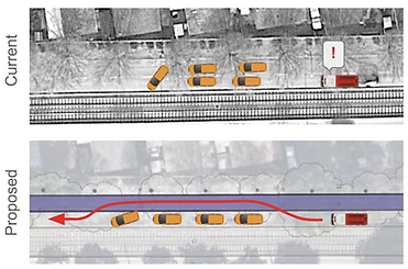
MOVING MOBILE HOMES WILL NOT BE A PROBLEM

A few times each year new mobile homes are transported in and out of the Casa De Amigos and Plaza Del Rey mobile home parks. They are moved on a wide-load truck during non-peak hours. These trucks only need a single lane to accommodate their wheelbase, with a few feet of unobstructed space for the parts that are overhanging. We have confirmed with a mobile home moving company that the proposed project will not be a problem for delivering mobile homes.

WHAT ABOUT EMERGENCY EVACUATIONS?
According to the City of Sunnyvale, one lane of Tasman Dr can carry a maximum of 900 vehicles/hour. With the completion of this project, there will be 2 outbound lanes on Tasman Dr, meaning the street would have a capacity of 1800 veh/hr. Assuming 1 vehicle per house, that’s 1700 vehicle/1880 veh/hr = ~1 hour to carry all of the traffic from both mobile home parks.
The limiting factor for evacuation time is not the number of traffic lanes on Tasman, but rather the number of exits from each park, which is not changing under this project. However, after a natural disaster, driving is not always the best option. This project enables people to evacuate on foot and by bicycle, which is faster and more efficient.
THIS PROJECT WILL ADD TREES
In early 2025, the City removed 23 beautiful trees on the North side of Tasman Dr between Fair Oaks Ave and Vienna Dr. The trees were a non-native species with particularly invasive roots, which were damaging water lines and properties in the Casa De Amigos mobile home park. This project will add up to 35 new trees (with less invasive roots) to Tasman Dr. They will provide shade and restore Tasman Dr's beautiful tree canopy.